Big Almaty Lake: The Turquoise Lake 30 Minutes from the City
Reported from the ground: Tugelbay Konabayev is a Kazakh native (born in Aktobe) who has lived 7 years in Almaty and 4 in Astana. About the author .
Can you actually visit Big Almaty Lake right now? Yes. Should you know about border-zone permits and access rules first? Yes. The lake sits 28 km south of Almaty in Ile-Alatau National Park, inside a sensitive border zone. Access is permitted for tourists, but the rules are real and worth understanding before you commit time or money.
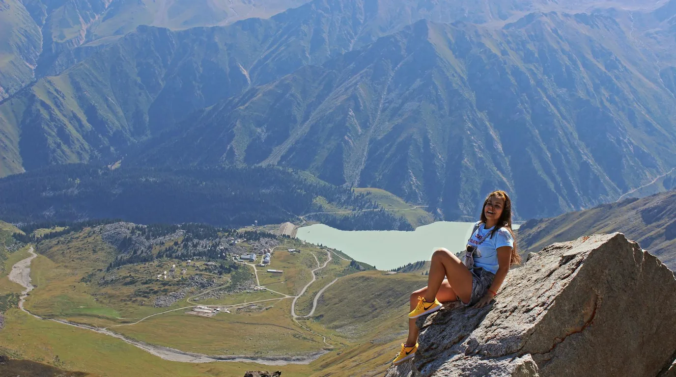
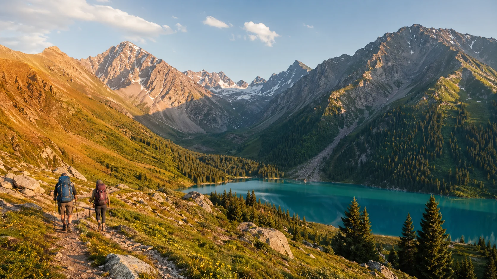
According to the Ile-Alatau National Park administration, Big Almaty Lake (Ulken Almaty Koli) is a tectonic alpine lake at 2,511 meters, formed by ancient earthquakes. It sits in a cirque surrounded by the Zailiysky Alatau range of the Tien Shan mountains. The water is turquoise from glacial flour suspended in melt from the Ozerniy glacier above. The lake is Kazakhstan's primary drinking water source for Almaty (2.2 million people), which is why entry rules exist and swimming is prohibited.
| Geographic Detail | Value |
|---|---|
| Elevation | 2,511 m (8,238 ft) |
| Lake dimensions | 1.6 km long, 1 km wide |
| Maximum water depth | 40 m (130 ft) |
| Distance from Almaty city center | 28 km due south |
| Elevation gain from city to lake | ~1,700 m |
| Drive time | 45-60 minutes |
| Road surface | Paved to road-end; maintained year-round in season |
| Border zone status | Yes; 25 km from Kyrgyz frontier |
Access Reality: Border Zone, Permits, and What You Need
The lake is 25 kilometers from the Kyrgyz border. This means: Entry to the national park is open to tourists, but there is an additional border-zone permit layer you should understand. Most tourists do not need extra paperwork if they arrive by tour or taxi (the companies handle it), but if you are renting a car or planning to stay in the valley, you need to know the rules.
According to Ile-Alatau National Park regulations, access to the lake itself is unrestricted for day visitors. However: a separate permit is required to enter the border-zone area (within 25 km of the Kyrgyz frontier), which includes the road to and around the lake. For foreigners on standard tourist visas (B-1, B-2), this permit is almost always approved automatically and is sometimes included in the national park fee. The process: (1) arrive at park entrance with your passport, (2) park rangers log your entry, (3) you receive a border-zone access stamp, (4) you visit the lake. Total extra paperwork: five minutes. Cost: included in park fees (600-1,000 KZT).
If you are on a longer-term residence visa (Digital Nomad B9-1, Temporary Residence Permit), the border-zone stamp still applies, but it may require advance notice. Check with your local migration office if staying more than 30 days.
What visitors cannot do: Cross into Kyrgyzstan, stray from marked paths into sensitive zones, or climb beyond the observatory trail without express permission. Enforcement is minimal for day tourists on the main trail, but the restriction exists.
Why the Lake Is That Specific Color
According to glaciologist Dr. Igor Severskiy (Institute of Geography, Almaty), the turquoise comes from glacial flour - microscopic rock particles ground by the Ozerniy glacier. Suspended in water, these particles scatter light in the blue-green spectrum. The same mechanism creates turquoise lakes in Banff, Canada and Jiuzhaigou, China according to UNESCO's World Heritage documentation. High-altitude alpine lakes worldwide show this effect when fed by active glaciers.
Color varies by season and melt rate:
- July-August: Peak vivid turquoise (maximum glacier melt, maximum suspended particles)
- June, early September: Strong blue-green but less intense
- May, late September: Lighter blue or milky blue-green
- October-April: Grey-green, brown, or white/frozen
Glacier melt is lowest in early spring and late autumn, so color fades. For peak turquoise, visit July or August.
Getting There: Five Routes, Each with Tradeoffs
The road is paved but steep. Elevation gain is 1,700 m in under 30 km. Altitude sickness is possible; take it slow. The route is: begin in Almaty (800 m), drive or walk south-southeast through lower foothills, enter Ile-Alatau at approximately 1,500 m, climb steeply into alpine zone, reach lake parking area at 2,511 m.
| Method | Duration | Cost | Road Fit | Best For |
|---|---|---|---|---|
| Taxi or ride-share | 45-60 min one way | 5,000-8,000 KZT each way ($10-16) | Paved; normal sedan okay | Solo travelers, first-time visitors |
| Organized half-day tour | 4-6 hours total (pickup to return) | $20-50/person | Tour van handles road | Groups, no driving stress, may include lunch |
| Rental SUV or sedan | 45-60 min one way | $40-60/day rental | Both work; SUV safer in rain | Flexibility, multiple lake visits, family groups |
| Bicycle from Medeu | 2-3 hours uphill; 1-1.5 hours down | Free (fitness only) | Road is paved; ~1,700m climb | Serious cyclists, want the summit-earned feeling |
| Bus #28 + walk | 4-5 hours total | ~500 KZT bus; rest is legs | Bus to road start; walk rest | Minimal budget, early morning only, full day commitment |
Reality: Most visitors taxi up, spend 1-2 hours at the lake, walk back down (2-3 hours, spectacular views the entire way, knees feel it). This is 5-6 hours total and costs $10-16 plus park entry. Many drivers wait and return you to the city; negotiate before you get in.
What Happens When You Arrive: The Lake's Water Status
Big Almaty Lake is a drinking water source first, tourist destination second. According to the Almaty city water authority, this lake and its watershed supply a significant portion of water for 2.2 million residents. This fact shapes three rules: no swimming, no water contact, no boats.
Swimming: Prohibited. The water is glacier-fed and ranges 8°C in July (the warmest month) to freezing in winter. Enforcement of the no-touch rule is inconsistent - many visitors touch the water for photos without penalty - but the rule exists because every person in the water affects millions of taps downstream.
Facilities: Minimal and intentionally sparse. One unpaved parking area at the viewpoint (capacity ~30 vehicles). One basic toilet block. No cafe, no shop, no restaurant at the lake. Bring all water, food, and layers you plan to need. The nearest food source is 10 km downhill at a cluster of yurt cafes (May-September only) serving tea (free if you order food), lagman (noodle soup, 800-1,200 KZT), and bread.
Crowds and timing: Weekday mornings 7-10 AM are nearly silent. Weekend afternoons fill with Almaty families. Park counts show 500+ visitors per day on July-August weekends. If you want the lake to yourself and still-water reflections, arrive by 8 AM any day of the week. Afternoon winds pick up around 10-11 AM and chop the surface.
What you actually see. The lake sits in a natural cirque (a U-shaped bowl carved by ancient glaciers). Peaks of the Zailiysky Alatau surround it on three sides. The highest visible summit is Pik Sovetov at 4,317 m. On clear days the scale is absolute. The rock is grey, bare, and steep. Wind and silence are intense. Most visitors spend 30-60 minutes looking, photographing, and absorbing the height before turning back or continuing uphill.
Photography: What Actually Works
The light, the wind, and the rules change the shots you can get.
Sunrise light (5-7 AM): The best light. Mountains glow orange and pink. The water surface is mirror-still before wind picks up around 10 AM. You need to leave Almaty by 4:30 AM and arrive by 6:30 AM. This requires a driver or pre-arranged early taxi the night before.
West shore angle: The classic postcard view - lake in foreground, peaks reflected in water, cirque walls framing the composition. Position yourself on the west/left side of the parking area and shoot east. The reflection works best on windless mornings (before 10 AM).
Overcast days: Counterintuitively, these work well. The turquoise color pops more without harsh sun shadows. Flat light removes the glare that happens on clear afternoons.
Drones: Park rules require advance permission to fly. According to Ile-Alatau National Park administration, an official permit exists but is not commonly granted for tourist photography. In practice, many people fly drones and encounter no enforcement, but technically you should request permission at the park entrance. Do not assume it is allowed.
Camera and phone batteries: Cold temperatures drain batteries 30-50% faster. Bring extras or external power. The temperature drop from city (25°C) to lake (5-10°C) stresses electronics.
Beyond the Lake: Trails and What They Offer
The lake is not the end. Several marked trails continue uphill if you have energy and time.
| Trail Name | From Lake | Total Distance from City | Elevation Gain from Lake | Difficulty | What You See |
|---|---|---|---|---|---|
| Tien Shan Observatory | 3 km (45 min walk) | 31 km | 224 m to 2,735 m | Moderate | Panoramic 360-degree view, Soviet-era telescope building, research scientists |
| Ozerniy Glacier | 6 km (2 hours) | 34 km | 700+ m to 3,200+ m | Hard | The glacier that feeds the lake's turquoise color, ice fields, technical climbing |
| Furmanov Peak | 8 km (3 hours from observatory route) | 39 km | 800+ m to 3,050 m | Hard | Highest viewpoint near Almaty, 360-degree vista, can see into Kyrgyzstan |
| Kok Zhailau meadow | Different road; Medeu base | 20 km from city | Moderate | Alpine wildflowers (June-August), gentle slopes, less crowded than lake |
Altitude Reality
You are going from 800 m (Almaty city) to 2,511 m (lake) in approximately 45 minutes by vehicle - a 1,700 m jump. Some people experience mild altitude sickness: headache, light shortness of breath, fatigue. According to Wilderness Medicine Society guidelines, this elevation is where symptoms first appear in sea-level people. Solution: take it slow, drink water (altitude dehydrates you faster), do not run uphill, rest for 1-2 hours before hiking further up. If you have a history of altitude sickness, take it very seriously and consider not continuing past the lake.
What to Bring and What Happens Month by Month
Packing for a 1,700 m elevation jump requires thinking about the delta, not the city temperature.
| Bring | Why | Consequence of Forgetting |
|---|---|---|
| Warm layers (fleece, down) | Lake is 10-15°C cooler than Almaty. Wind adds chill factor. | Discomfort, hypothermia risk if wet |
| Sunscreen (SPF 50+) + hat | UV intensity at 2,500m is 40-50% higher than sea level. Burn happens in 20-30 min. | Severe sunburn, affects next 3-5 days |
| 1.5-2 L water | No water for sale at lake. Altitude dehydrates. | Dehydration, headache, slower hiking, exhaustion |
| Snacks (nuts, energy bar, fruit) | Food at lake does not exist. Only yurts 10 km downhill. | Bonking (energy crash), slower descent, injury risk |
| Cash in KZT only | Park entrance fee 600-1,000 KZT. No card machines. No USD accepted. | Cannot enter park; turnback at gate |
| Extra phone/camera battery | Cold drains 30-50% faster than in the city. | Dead phone mid-hike or no photos |
| Rain jacket | Afternoon thunderstorms are possible May-September. Rapid weather change. | Hypothermia, forced descents in danger |
Best Time to Visit: Month-by-Month Reality
| Month | Turquoise Color | Road Status | Lake Temp | City Temp | Rating | Key Notes |
|---|---|---|---|---|---|---|
| May | Pale blue, may be partially frozen | Opening, snow patches possible | 5-10°C | 15-20°C | Fair | Late melt; color not yet peak |
| June | Turning vivid | Clear | 10-15°C | 20-25°C | Great | Good light, fewer crowds than peak |
| July-August | Peak vivid turquoise | Clear | 15-20°C | 25-35°C | Best | Most visitors, most reliable weather |
| September | Still vivid but fading | Clear | 8-15°C | 15-25°C | Great | Pleasant crowds drop, still gorgeous |
| October | Blue fading to grey | May close mid-month | 0-8°C | 5-15°C | Fair | First snow possible; unpredictable |
| Nov-April | Frozen solid or grey | Closed by snow | Below 0°C | Below 0°C | Closed | Road impassable; no vehicle access |
Peak season (July-August): Most visitors, clearest skies, warmest lake, but 500+ visitors per day on weekends. Sweet spot (June, early September): Excellent color, lighter crowds, still warm enough for comfort.
Adding Other Destinations to Your Day
Big Almaty Lake consumes 5-6 hours solo. Other nearby mountains exist but are on different roads or require day-splitting.
Same-Direction Combinations
Medeu and Shymbulak: Different valley (west of Big Almaty Lake valley), different road, same general south direction from Almaty. Medeu is a skating rink and bobsled track at 1,700 m; Shymbulak is a gondola and skiing area above it. These are easier (less altitude) and busier than the lake. You can visit both Medeu/Shymbulak AND Big Almaty Lake in a single day by: (1) morning taxi to Medeu/Shymbulak (45 min), spend 2 hours, (2) taxi to Big Almaty Lake (30 min between valleys), spend 2 hours, (3) return to city. Total: 8 hours. Doable but compressed.
Tien Shan Observatory: Already described above - 3 km further uphill from the lake, adds 45 minutes each direction if you hike it.
Different-Direction Alternatives
Charyn Canyon: 200+ km east; separate full day. Not combinable with the lake on the same day.
Turgen Waterfall: East of the city; separate day.
Kok Zhailau meadow: Accessible from Medeu valley; wildflowers June-August; easier than the lake (only 2,300 m elevation). Better for families.
See our complete Almaty day-trips guide for detailed combinations, costs, and multi-destination itineraries. According to best time to visit Almaty and Lonely Planet's Kazakhstan coverage, July-August open the most destinations and trails simultaneously.
The Park System: What You Are Actually Entering
Big Almaty Lake is part of Ile-Alatau National Park, a 199,700-hectare (492,000-acre) protected reserve. Established in 1996, it sits between Almaty city and the high Tian Shan, protecting the watershed and alpine ecosystems. The park extends from 1,000 m elevation (northern edge) to peaks above 4,500 m (southern Kyrgyz border). According to park administration data, it protects 1,000+ plant species, 200+ bird species, and large mammals: brown bear, snow leopard, ibex, and argali sheep.
Visitor reality: Over 300,000 people enter the park annually - one of Central Asia's busiest protected areas. Most visit the lake or Medeu; few venture into deep wilderness trails. The park has ranger stations, marked trails, and designated camping zones.
Fees and Documentation
- Park entrance: 600-1,000 KZT ($1.50-2.50 USD). Covers all day-access zones, including the lake.
- Border-zone permit: Included in entrance fee for day visitors on standard tourist visas. Automatic approval at the gate (5 minutes).
- Camping or overnight stays: Different permit; approximately 2,000-3,000 KZT. Not required for same-day visits.
- Payment: Cash KZT only. No cards at the gate. Plan accordingly.
The Zone You Cannot Enter
The area beyond the lake heading toward the Kyrgyz border is increasingly restricted. The park boundary itself is the border at 25 km south; you cannot cross. Trails like Ozerniy Glacier approach but do not cross the line. Enforcement is loose for day hikers on marked trails, but straying into sensitive zones or attempting to hike to the actual border carries fines or detention risk (rare but real).
Why the Rules Exist: Water Security and Glacier Health
The lake is not just a photograph location. It is Almaty's primary drinking water source for 2.2 million people. According to the Almaty city water authority, the lake's water and its watershed feed a pipeline system to homes and industry across the city. The Ozerniy River flows downhill and enters the system below the park. This is why no swimming, no water contact, no boats are allowed. It is not bureaucracy; it is hydrology.
The longer crisis: The glacier feeding the lake is shrinking. According to Kazakh Institute of Geography research, the Ozerniy glacier has retreated 15-20% over the past 50 years - measured by satellite comparison. Less glacier mass means less summer melt. Less melt means less water in the lake and less water reaching the city during dry months. The turquoise color visitors come for is actually an indicator of glacier health. When the color fades to grey or the lake dries, it signals glacier loss.
What you can do: Stay on marked paths, pack out all trash, avoid the shoreline. Rangers are stationed on busy summer weekends to enforce this. More importantly, the visibility of climate change in this lake - year after year of fading color and lower water levels - makes it a direct climate education site. Photograph it. Tell people why it matters.
The broader context: According to UNESCO's research on mountain water sources, high-altitude glacial lakes like this one feed entire cities in Central Asia. The loss of these glaciers is a regional water crisis unfolding in real-time. Kazakhstan is investing in water storage and treatment to adapt, but the core issue is geophysical: the glaciers are melting faster than they accumulate new ice.
Stopping Points: The Observatory and the Yurt Cafes
The main road to the lake passes two useful stops that extend your experience without adding much time.
Tien Shan Astronomical Observatory (3 km past the lake)
The observatory sits at 2,735 m - 224 m above the lake - and is reachable by road (rough final stretch) or 45-minute walk from the lake parking area. Built in 1957 during the Soviet era, it houses multiple telescopes and functions as an active research facility. It is not always open to the public for tours, but the building and the panoramic plateau are accessible to any visitor willing to walk up. The view from the observatory platform spans the entire Zailiysky Alatau ridge on clear days. Most visitors spend 30-45 minutes here if they hike from the lake; vehicle access is limited.
Yurt Cafes in the Lower Valley
The approach road passes through lower Ile-Alatau valley where seasonal yurt cafes (May-September) operate. These offer tea (free if you order food), lagman (noodle soup, 800-1,200 KZT), bread, and dumplings. They serve as good rest stops before or after the lake - sitting with mountain views while eating hot food. Prices are local (cheaper than city), cash only.
Frequently Asked Questions
- How do I get to Big Almaty Lake from Almaty?
- According to distance measurements, the lake is 28 km south of Almaty center, 45-60 minutes by car. Options: taxi (5,000-8,000 KZT one way), organized tour ($20-50), rental car (SUV recommended), or bus #28 plus 13 km uphill walk. The road is steep with ~1,700m elevation gain.
- Can you swim in Big Almaty Lake?
- No. According to Ile-Alatau National Park regulations, swimming and touching the water are prohibited because the lake is a drinking water reservoir for Almaty. The water is also glacier-fed and extremely cold year-round.
- Why is Big Almaty Lake turquoise?
- According to glaciologist Dr. Igor Severskiy, the color comes from glacial flour - microscopic rock particles ground by the Ozerniy glacier that scatter light in the blue-green spectrum. The color is most vivid in July-August when glacier melt is at its peak.
- What is the best time to visit Big Almaty Lake?
- According to seasonal conditions, July and August offer the most vivid turquoise color and warmest temperatures (15-20°C at the lake). The road is typically open from May to October. November through April the road is closed by snow.
- Is Big Almaty Lake free to visit?
- According to park fees, there is a small Ile-Alatau National Park entrance fee of approximately 600-1,000 KZT ($1-2). The main expense is transport from Almaty. A taxi runs $10-16 one way.
- Can I camp near Big Almaty Lake?
- According to park regulations, camping at the lake itself is not permitted as it is a protected water source. Designated camping areas exist lower in the valley within Ile-Alatau National Park. The lake is best visited as a half-day trip from Almaty.
Last verified: March 2026
More Stories
nature
Lake Balkhash: Kazakhstan's Two-Toned Natural Wonder
Lake Balkhash is Central Asia's largest lake after the Aral Sea, famous for its half-fresh, half-salt water. Discover wildlife, travel tips, and ecology.
nature
Charyn Canyon: Kazakhstan's Answer to the Grand Canyon
Charyn Canyon guide - Valley of Castles, how to get there from Almaty, best time, hiking, and why this 12-million-year-old gorge is worth it.
nature
Kazakh Steppe: Grassland, Wildlife & Nomadic Culture
The Kazakh steppe covers 800,000+ km², larger than France and Germany combined. History, wildlife, nomadic culture, and how to visit today.
nature
12 Best Hiking Trails in Kazakhstan: Difficulty & Costs
Kazakhstan hiking trails from easy day walks to multi-day treks. Difficulty ratings, costs ($5-$200), gear lists, best months for each region.
Plan the Next Step
travel
Almaty Travel Guide 2026: Things to Do, 3-Day Itinerary & Costs
Things to do in Almaty, Kazakhstan: 3-day itinerary, mountain sights, restaurants, hotels from $25, Charyn Canyon day trips, and local costs.
travel
Astana, Kazakhstan: 15 Sights, Prices & 2-Day Itinerary
Astana Kazakhstan sightseeing guide: Baiterek Tower, Khan Shatyr, mosques, museums, prices, opening hours, transport, and a 2-day itinerary.
facts
Kazakhstan Population 2026: 20.5M People, Ethnic Groups & Map
Kazakhstan population in 2026: 20.5 million people, ethnic groups, city rankings, growth rate, density, age structure, and UN projections to 2050.
nature
Mangystau, Kazakhstan: Mars-Like Cliffs, Tours & Costs (2026)
Mars-like white cliffs, underground mosques, 4x4 tours $50-200/day. Fly via Aktau. Local guide: routes, costs, best season for Mangystau Kazakhstan.
nature
12 Best Hiking Trails in Kazakhstan: Difficulty & Costs
Kazakhstan hiking trails from easy day walks to multi-day treks. Difficulty ratings, costs ($5-$200), gear lists, best months for each region.
nature
Kazakh Steppe: Grassland, Wildlife & Nomadic Culture
The Kazakh steppe covers 800,000+ km², larger than France and Germany combined. History, wildlife, nomadic culture, and how to visit today.

Travel Writer & Local Expert · Almaty, Kazakhstan
Tugelbay Konabayev is a Kazakhstan-based travel writer who has lived in Almaty for 7+ years and Astana for 4+ years. He grew up in Aktobe, Kazakhstan and has covered Kazakh travel, food, culture, and visa policy with first-hand reporting since 2023.