Karkaraly National Park: Planning a Visit from Town
Reported from the ground: Tugelbay Konabayev is a Kazakh native (born in Aktobe) who has lived 7 years in Almaty and 4 in Astana. About the author.
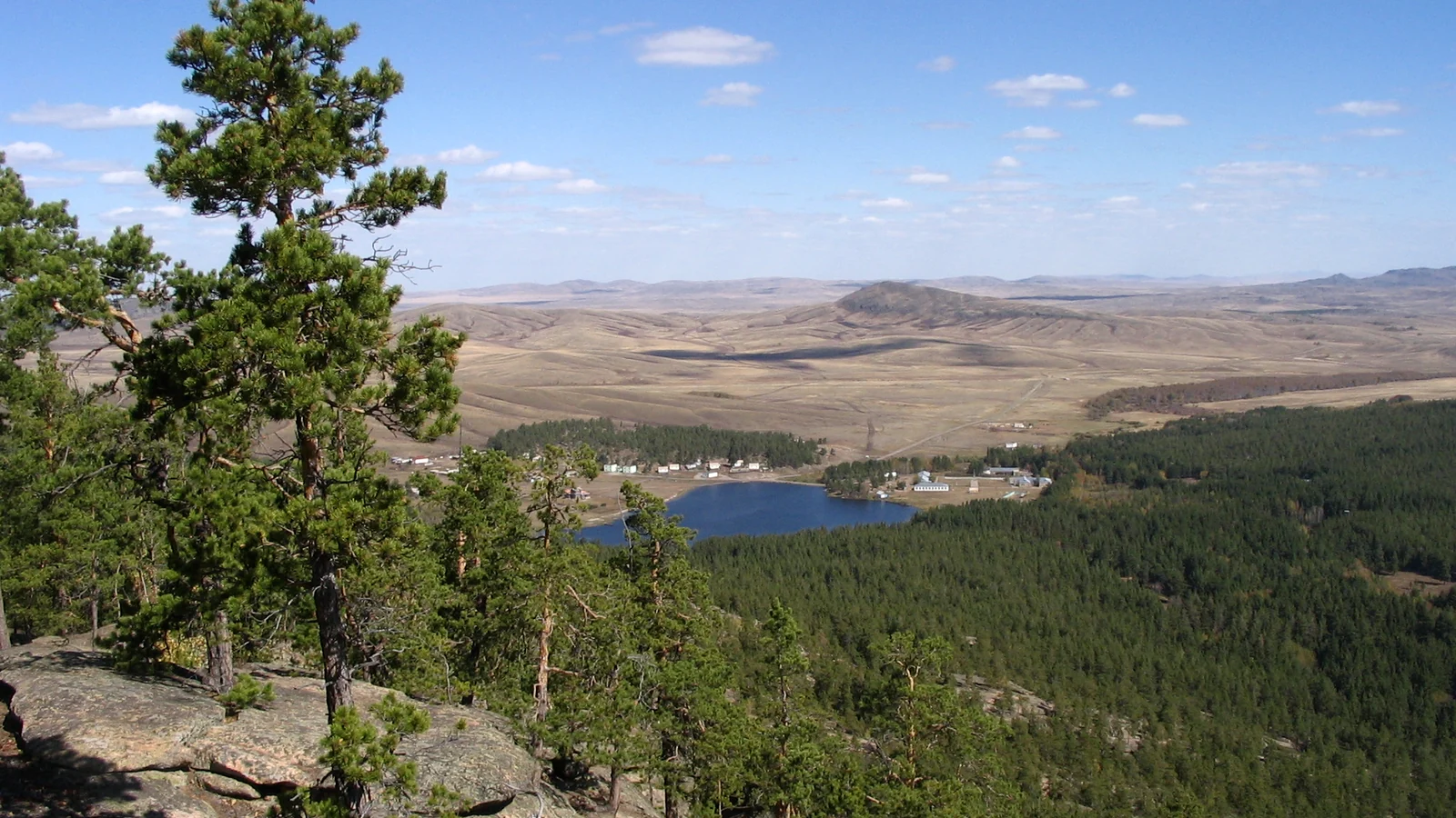
In this article4 sections
Karkaraly is a forest-and-lake trip from Karaganda Region, with Karkaraly town as the practical base. The park includes the Karkaraly and Kent mountain forests, so first choose a specific permitted route. Do not assume every point marked inside the protected area is freely accessible.
Cover: Karkaraly landscape, photographed by Wassily, CC BY-SA 3.0. Cropped and contrast adjusted for this page; derivative shared under the same license.

| Time | Better plan | Check |
|---|---|---|
| One day | Town plus one park-approved walk | Trail start, return time and weather |
| Two days | Separate forest/lake and heritage stops | Lodging and route access |
| More time | Consider Kent as a distinct excursion | Vehicle, park zone and guide requirements |
Map names: Қарқаралы / Каркаралы (Karkaraly), Қарқаралы ұлттық паркі (national park), Кент (Kent), Шайтанкөл (Shaitankol). Search the exact route or trailhead, not only the national-park polygon.
What the park protects
The Kazakh-language QazaqGeography park profile cites the government resolution establishing Karkaraly National Park on 1 December 1998. A Kazakhstan government profile confirms the 112,120-hectare area and names the Tau, Karkaraly, Kent and Bakty forest divisions. The park has zones with different conservation and visitor uses; a national-park boundary is not an invitation to walk anywhere inside it.
The attraction is the contrast between pine-covered granite uplands and the surrounding steppe, with lakes and local history adding reasons to stay. The Karkaraly and Kent forests are separate parts of the park. Ask which route fits your fitness, season and available transport; avoid copying an online loop without checking whether it crosses a restricted zone.
The QazaqGeography profile says the park maintains four visitor routes totalling 70.4 km of out-and-back travel. That total is not one trail length. Request the current route list and starting points from the park before choosing a walk; this source does not publish a current fee or a route-by-route timetable.
The government profile names Shaitankol, Lake Bassein (озеро Бассейн) and Pashennoye among the park’s lakes. A Kazakhstan hiking operator’s 2018 account describes a route involving these names, but its track, fee and access experience are historical. The government page confirms the landscapes, not a current walking itinerary between them.
A workable visit
Start in Karkaraly town. Confirm accommodation, the park’s current visitor contact, trail status and whether a guide or entry payment is needed for your chosen route. For a short stay, pick one trail with a clear start and finish and leave time to return before dark. Shaitankol may be an appealing named destination, but check the current route from your actual trailhead; a map label does not establish walking time.
For the wider journey, use our Karaganda city guide and confirm the onward connection to Karkaraly separately. A taxi to “the park” is not a route plan; give the driver the approved trailhead and a return pickup point. If you want several trails or Kent, an overnight town base is more useful than a rushed day from Karaganda.
Carry water and a downloaded map. Weather can change quickly on the exposed rock and in forested valleys. Check Kazhydromet and any fire or route notices. A driver should know the return pickup point. Do not assume a taxi can be called from inside the park.
Lakes, forest and Kent: what is actually documented?
The named lakes are real; their current route details still need a park-issued itinerary. The recent government profile names Shaitankol, Bassein and Pashennoye. QazaqGeography reports four marked tourist routes and a 70.4 km total for all routes together, without a current route-by-route table. Do not interpret that figure as one walk. Ask the park which named lake is on an open route, where the trail starts and whether the return uses the same path.
Kent is a different part of the park, with an archaeological layer. QazaqGeography’s park profile describes remains of a Bronze Age settlement in the Kent forest division. That makes a Kent excursion distinct from a lake walk near Karkaraly town. The profile does not establish a current visitor route through the archaeological area; confirm zone access, road and guide arrangements before adding it to a second day.
| Aim | Source-backed anchor | Still to confirm |
|---|---|---|
| Forest and lake walk | Shaitankol, Bassein or Pashennoye named by the government | Open route, start, distance and return pickup |
| Kent and archaeology | Kent forest and settlement remains in QazaqGeography | Zone access, road and visitor route |
| Short stop | Karkaraly town as a practical base | Whether transport leaves enough daylight for a walk |
For a lake-first alternative in Pavlodar Region, compare Bayanaul in the Kazakhstan national parks guide. These are different regional trips, so choose by your wider route rather than an imagined afternoon transfer.
Sources checked
- QazaqGeography: Karkaraly National Park profile in Kazakh
- Kazakhstan government: Karkaraly park profile
- Adrenalinic Silence: Kazakhstan hiking account including Lake Bassein (2018)
- Kazhydromet: current forecast
Frequently Asked Questions
When was Karkaraly National Park founded?
QazaqGeography cites the government resolution of 1 December 1998. The government park profile cited above gives an area of 112,120 hectares.
Is Karkaraly a day trip?
A single approved walk may fit a day if your transport is arranged. Add an overnight stay if you want multiple trails or the Kent area.
Can I hike anywhere inside the park?
No blanket access should be assumed. The park has zones with different uses. Confirm the selected route, entry and guide rules locally.
Last reviewed: September 2026. Park access and routes can change.
Google Preferred Sources
See more Kazakhstan stories in Google
Add About Kazakhstan as a preferred source to find more of our fresh, relevant stories in Google Search.
More Stories
nature
Aksu-Zhabagly Nature Reserve: Guided Visit Planning
Plan a permitted visit to Aksu-Zhabagly: confirm an available ecological route, arrange a guide in advance and understand the reserve's visitor rules.
nature
Bayanaul National Park: Four Lakes and Named Routes
Choose between Jasybay and the other Bayanaul lakes, plan a realistic trip from Pavlodar Region, and check park access using local official sources.
nature
Lake Zaysan, Kazakhstan: Shore Access and Trip Planning
Plan a visit to Lake Zaysan in eastern Kazakhstan: distinguish the lake from Zaysan town, choose a shore, and verify roads, weather and local services.
nature
Turgen Gorge from Almaty: Bear Falls, Kairak and Road Guide
Plan Turgen Gorge from Almaty: choose the short Bear Falls walk or the long Kairak hike, and check park access, transport and weather.
Plan the Next Step
travel
Kazakhstan Tourist Attractions: Choose the Right First-Trip Route
Compare Kazakhstan tourist attractions by base and logistics: Almaty nature, Turkestan heritage, Mangystau, Astana, Baikonur, and more.
food
Beshbarmak Recipe: How Kazakh Et Is Served
A source-checked guide to Kazakh et, widely called beshbarmak: what is on the platter, a practical home recipe, regional differences, and guest etiquette.
food
Popular Food in Kazakhstan: 15 Foods and Drinks to Try
Popular food in Kazakhstan explained: 15 Kazakh dishes and drinks, what each contains, how meals are served, and what to ask before ordering.
nature
Lake Balkhash Travel Guide: Two Waters, One Lake
A source-checked Lake Balkhash guide: why west and east differ, Kazakhstan's 2026 water update, a realistic trip plan, and swimming and fishing boundaries.
nature
Mangystau, Kazakhstan: Routes, Seasons and Trip Costs
Plan a Mangystau expedition from Aktau with current route, season, operator, sacred-site, safety and quote-check guidance for 2026.
nature
Kazakh Steppe: Landscape, Wildlife and How to Visit
Source-checked guide to the Kazakh steppe: its extent, Saryarka, Korgalzhyn, 2025 saiga data, seasons, and responsible access.

Travel Writer & Local Expert · Almaty, Kazakhstan
Tugelbay Konabayev is a Kazakhstan-based travel writer who has lived in Almaty for 7+ years and Astana for 4+ years. He grew up in Aktobe, Kazakhstan and has covered Kazakh travel, food, culture, and visa policy with first-hand reporting since 2023.