Lake Zaysan, Kazakhstan: Shore Access and Trip Planning
Published by About Kazakhstan. Read about our sources, author, and corrections. About the author.
In this article5 sections
Lake Zaysan is a large eastern Kazakhstan lake, not a single beach or a town-centre waterfront. Pick a specific accessible shore and overnight base before setting out. The town of Zaysan and the lake share a name; an address in one does not automatically put you beside the other.
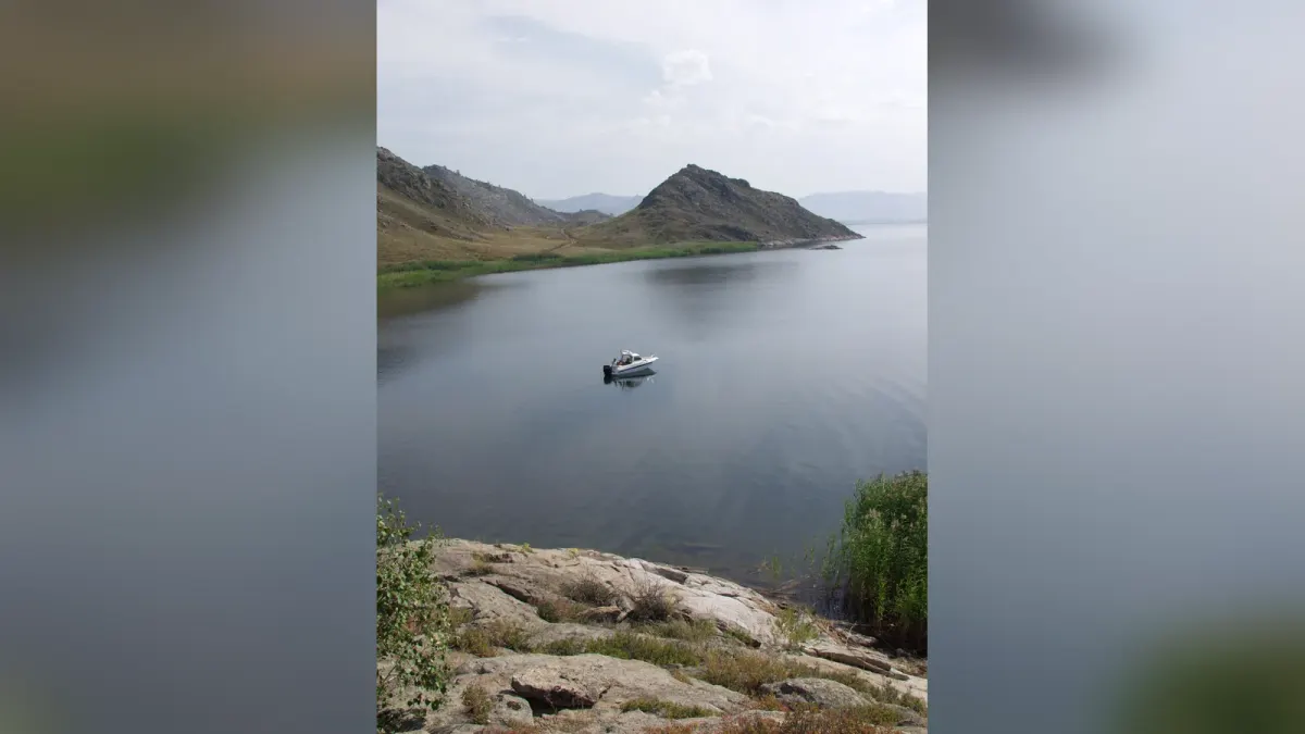
Cover: Lake Zaysan photograph by 7777777kz, CC BY 3.0. Resized, contrast adjusted and framed with blurred extensions from the same photograph.

| Decision | Ask before booking | Why it matters |
|---|---|---|
| Which shore? | Exact map pin and current road access | The lake has many possible approaches |
| Which base? | Distance from lodging to the intended shore | “Zaysan” may mean the town or lake area |
| What activity? | Local rules for swimming, boats or fishing | Conditions and permissions differ |
| What season? | Weather, ice and road status | Open-water plans are seasonal |
Map names: Зайсан көлі / озеро Зайсан (Lake Zaysan), Зайсан қаласы / город Зайсан (Zaysan town), Өскемен / Усть-Каменогорск (Oskemen). Copy the exact shore pin as well as the name.
What to expect
Expect a broad lake basin with several possible approaches, not one signed public beach. Plan from a named shore or operator itinerary.
The East Kazakhstan regional tourism board’s Kazakh-language lake page describes a broad lake basin between mountain ranges. It gives an area over 1,800 square kilometres, but lake and reservoir boundaries make a single unsourced present-day area misleading, so use that only as the board’s reference figure. The board says the lake usually freezes from November to April; that is not a guarantee that ice or open water is safe on your date.
For one named shore plan, the tourism board’s “Golden Ring of Zaysan” itinerary travels via Kurchum and Amanat to Shekelmes Cape (мыс Шекельмес), then camps by the lake. This is an operator itinerary, not a promise that an independent car can reach the same camping place or that its listed services are current. Ask an operator for the exact shore pin, vehicle requirements, overnight arrangement and return route. The board’s lake page gives a long road approach from Oskemen; figures may refer to different shores or Zaysan town.
An optional wider landscape route pairs Shekelmes with Kiin-Kerish (Қиын-Керіш), a separate area of coloured clay formations. A 2023 East Kazakhstan field report describes both places in one Kurchum District journey and warns that rain makes clay roads difficult. This is a dated trip example, not a current road report or a requirement for seeing the lake. Keep the extra stop only if the operator confirms a suitable vehicle, route and time.
Check the Bukhtarma crossing on current maps
An older itinerary and a newer government bridge notice describe different transport eras. The tourism-board itinerary still mentions a Kaznakovka ferry. Kazakhstan’s government reported opening a road bridge across Bukhtarma Reservoir in October 2024, connecting the Kurchum and Zaysan districts with other eastern districts. Confirm whether your proposed crossing is the one affected by the bridge and which road is now used; the two sources alone do not establish a complete current route to your shore. Avoid treating the lake as a simple afternoon detour from Oskemen.
If an operator still lists the ferry, ask for a current map and quote. Confirm whether the trip reaches Shekelmes, another shore, or simply Zaysan town. The tourism-board itinerary is a named multi-stop tour; the bridge notice does not confirm today’s condition of an individual lakeside track.
A practical visit
Secure a precise shore pin and return route before reserving a room. The town name, lake name and campsite name may point to different places.
For a first trip, book a base with a confirmed route to the water and an answer about food, fuel and mobile coverage. Spend a day on the chosen shore, with time left for the return drive. For boating or fishing, ask a current local provider about conditions and any applicable rules; the tourism board’s general description is not a permit. Do not promise yourself an ice excursion from a generic winter travel page.
Check Kazhydromet before departure. Strong wind, cold water and remote roads can change the day’s plan. Bring water and offline maps, and avoid driving across unverified shoreline tracks. For other lake options closer to established routes, compare our Kazakhstan nature guide.
Our Lake Balkhash guide covers a different lake journey; compare the actual shore approach before treating either lake as a beach stop.
If your route approaches the Chinese border, ask a current local operator whether any border-zone restrictions apply to the specific shore or road you plan to use. We have not verified a blanket permit rule for every Zaysan lakeside location. Oskemen can be a transport gateway, but its city sights and a Zaysan shore trip need separate days and logistics.
A concrete enquiry for the eastern route
Use the regional tourism board’s Golden Ring of Zaysan itinerary as the contact and route reference. Ask about Shekelmes Cape / мыс Шекельмес, with the named Kurchum–Amanat approach, rather than booking a room merely labelled “Zaysan”. Map search: Shekelmes Cape helps compare names but is not verified off-road navigation.
A sensible enquiry is: “Can you confirm a trip to Shekelmes for [date], the present Bukhtarma crossing, the exact shore pin, suitable vehicle, overnight location, food, fuel and the return to [base]?” Ask for a current map if the proposed itinerary still mentions the older ferry. The official bridge-opening notice does not certify the final shore track.
For a first visit, organise the approach and overnight separately from time on the lake. Treat Kiin-Kerish as an optional extension only if the operator confirms the clay-road conditions and enough daylight. If that extension falls through, a confirmed shore visit can remain the main trip; if the shore access itself is uncertain, postpone the remote leg rather than assuming Zaysan town is a lakeside substitute.
Sources checked
- East Kazakhstan tourism board: Lake Zaysan in Kazakh
- East Kazakhstan tourism board: Golden Ring of Zaysan itinerary
- Kazakhstan government: Bukhtarma bridge opening, October 2024
- East Kazakhstan field report: Kiin-Kerish and Shekelmes, September 2023
- Kazhydromet: current forecast
Frequently Asked Questions
Is Lake Zaysan in Zaysan town?
The town is one possible base, but the lake has many shores. Check the route to your chosen shore rather than assuming a town address is on the water.
Can I swim in Lake Zaysan?
Do not assume every shore is a managed swimming beach. Ask a local provider about the specific access point, water conditions and any restrictions.
Is Lake Zaysan an easy day trip from Oskemen?
It is a long regional journey. The travel time depends on the specific shore and road, so an overnight base is usually the safer plan.
Last reviewed: 2 October 2026. Map links are searches, not field-verified access pins. Confirm conditions at the specific shore.
Google Preferred Sources
See more Kazakhstan stories in Google
Add About Kazakhstan as a preferred source to find more of our fresh, relevant stories in Google Search.
More Stories
nature
Burabay, Kazakhstan: Lakes, Trails & Trip Planning
Plan a Burabay escape around one flexible park day, live weather and access checks, lake viewpoints, marked trails, hotels, and a safe return.
nature
Kolsai Lakes, Kazakhstan: Hiking & Lake Kaindy Side Trip
Plan Kolsai Lakes from Almaty: hiking routes, Saty stays and park fee checks. Visiting Lake Kaindy too? Find its separate sunken-forest route and access guide.
nature
Lake Kaindy, Kazakhstan: Sunken Forest & Saty Access Guide
Plan Lake Kaindy from Saty or Almaty with the park's official 11 km route, river crossings, walking approach, live fee check and safety rules.
nature
Mangystau, Kazakhstan: Routes, Seasons and Trip Costs
Plan a Mangystau expedition from Aktau with current route, season, operator, sacred-site, safety and quote-check guidance for 2026.
Plan the Next Step
travel
Kazakhstan Tourist Attractions: Choose the Right First-Trip Route
Compare Kazakhstan tourist attractions by base and logistics: Almaty nature, Turkestan heritage, Mangystau, Astana, Baikonur, and more.
food
Beshbarmak Recipe: How Kazakh Et Is Served
A source-checked guide to Kazakh et, widely called beshbarmak: what is on the platter, a practical home recipe, regional differences, and guest etiquette.
food
Popular Food in Kazakhstan: 15 Foods and Drinks to Try
Popular food in Kazakhstan explained: 15 Kazakh dishes and drinks, what each contains, how meals are served, and what to ask before ordering.
nature
Lake Balkhash Travel Guide: Two Waters, One Lake
A source-checked Lake Balkhash guide: why west and east differ, Kazakhstan's 2026 water update, a realistic trip plan, and swimming and fishing boundaries.
nature
Mangystau, Kazakhstan: Routes, Seasons and Trip Costs
Plan a Mangystau expedition from Aktau with current route, season, operator, sacred-site, safety and quote-check guidance for 2026.
nature
Kazakh Steppe: Landscape, Wildlife and How to Visit
Source-checked guide to the Kazakh steppe: its extent, Saryarka, Korgalzhyn, 2025 saiga data, seasons, and responsible access.

Creator of About Kazakhstan
Tugelbay Konabayev is a digital marketer and content strategist from Aktobe, Kazakhstan, and the creator of About Kazakhstan. The site's research guides bring together local-language and primary sources for English-speaking readers. Sources and review dates identify what each article can support.